
The future starts with an accurate map.
Rapid, accurate mapping for challenging applications. AutoMap builds SLAM hardware and cloud software that turn complex real-world assets into precise, colourised digital twins — underground, above-ground, and everywhere GPS can't reach.
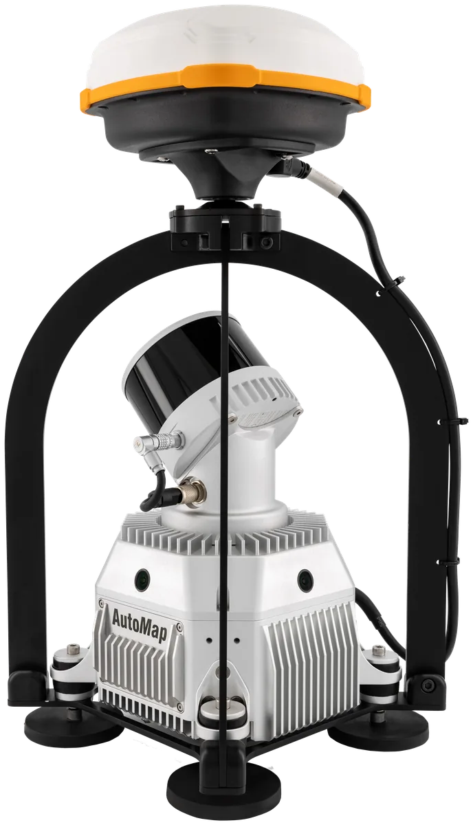
Built for accuracy where it's hardest to get.
Four engineering choices make every AutoMap capture reliable — whether it's a high-rise stairwell, a 12 km tunnel, or a moving rover.
WildcatSLAM accuracy
Ultra-low-drift simultaneous localization and mapping, refined for years in production environments.
RTK and PPK GPS fusion
Seamless transitions between GPS-available and GPS-denied spaces while keeping global accuracy.
4K colourisation
360° hardware-synchronised cameras paint every point with true-colour context — not just geometry.
Stream-to-cloud
Captures move from the device to OrbisFuse without an office stop. Share, measure, annotate in minutes.
See AutoMap in action.
Real captures from mines, plants, roads, and construction sites — every clip mapped with AutoMap hardware and OrbisFuse.
In this series
10 videosOne platform, three instruments.
Choose the sensor pack that fits the environment. All three pipe directly into OrbisFuse.
VellusX
The world's most accurate SLAM mapping system. Walk it, drive it, or mount it on a robot. RTK and PPK GPS fusion keeps coordinates honest across every transition.
TerrusM
Award-winning underground capture. Waterproofed and built for harsh environments — shafts, declines, drawpoints, and everything in between.
OrbisFuse
Browser-based storage, viewing, measurement, and sharing for every map you capture. Unlimited users. Drop in. Measure. Done.
VellusX or TerrusM — pick by environment.
Both stream into OrbisFuse and run the same WildcatSLAM engine. The environment you capture decides the sensor pack.
| VellusX Versatile · Precise | TerrusM Tough · Rugged | |
|---|---|---|
| LiDAR | Rotating Hesai XT32-M2X | Rotating Velodyne VLP-16 |
| Range | 300 m | 100 m |
| Points / second | 1.8M (triple return) | 600K (dual return) |
| Weight | 3.7 kg | 2.4 kg |
| IP rating | IP64 | IP64 |
| Global accuracy | RTK & PPK GPS fusion | Survey control (GCPs) |
| Best for | Roads, streetscapes & large outdoor capture | Mines, tunnels & confined spaces |
From mine shafts to motorways.
Six domains where teams ship faster with an accurate map.
Plant digitization
Turn complex industrial facilities into navigable digital twins for maintenance, retrofit planning, and operator training.
Underground mapping
Capture survey-grade maps in GPS-denied environments — mines, tunnels, and subterranean infrastructure — without sacrificing accuracy.
Road scanning
Mobile-mounted capture of road corridors with RTK and PPK GPS fusion for grid-aligned outputs and rapid coverage.
Building documentation
Walk through a structure once to produce a colourised point cloud suitable for BIM, facilities management, and as-built records.
Shaft inspection
Lower the sensor pack into shafts, declines, and drawpoints to capture geometry where human access is unsafe or impractical.
AEC
Architecture, engineering, and construction teams use AutoMap to verify progress against design and to share spatial data instantly.
Our Partners


Bring an accurate map to your next project.
We work with surveyors, miners, architects, roboticists, and infrastructure teams worldwide. Tell us about your environment — we'll recommend the right capture setup.
Industry articles.
Field notes and technical write-ups from the AutoMap team — on SLAM accuracy, survey control, and the environments GPS can't reach.
Complex Infrastructure
Replacing 200+ static setups with an hour of walking — how a mobile SLAM backpack captures bridges and urban cityscapes without closing a single road.
Read articleSurvey Control for Global Accuracy
Tying GPS-denied SLAM captures to known survey control so underground and indoor maps meet real-world accuracy requirements.
Read articleDetailed Digital Twins
Where drones can’t fly — indoors, underground, in confined plant — ground-based mobile LiDAR builds the colourised digital twin instead.
Read articleLow Detail Subterranean Areas
A repeatability study through the Ernest Junction Railway, proving how consistently TerrusM holds its odometry in low-detail tunnels.
Read articleLinear SLAM Mapping
Mapping Wolston Rd end-to-end to measure how WildcatSLAM’s odometry performs over long, feature-light linear surface routes.
Read articleAutonomous Inspection Vehicle
Mounting an AutoMap scanner on an autonomous rover — developed with BIA5 — to map and inspect large sites repeatedly, with no operator on the loop.
Read articleSurvey Mapping
Why repeatability — not a single accurate capture — is the SLAM characteristic that makes a map trustworthy enough to survey against.
Read articleUnderground Localisation
An overview of the failure modes that decide whether a SLAM localisation holds underground — slip, drift, aliasing and global repeatability.
Read article